
REPORT - BikeMaps.org Evaluation
- Read more about REPORT - BikeMaps.org Evaluation
- Log in to post comments
 BikeMaps.org is a crowd sourced map of cycling collision data worldwide. Incidents of collisions, near misses, hazards and thefts can be entered via the web site or through the free Android or Apple apps. The data collected is available to all. If you choose to register and log in, it will even alert you to recent incidents mapped in your area.
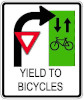
 QUESTION: Eastbound on Point Grey at Alma there are two bike lanes on the north side of the street that are allowed to cross Alma without stopping. Cars eastbound on Point Grey must turn either right or left, and there is a curb/diverter on the far side to prevent them going straight through.
 Question: I was driving at the intersection of 2nd Avenue and the Cambie Street on ramp in Vancouver. I turned right on a green light to head onto Cambie Street. I did not have to yield to any pedestrians as they were being held by the pedestrian signal. I moved about 20 feet into turn and my car was struck on the passenger side by a bicyle rider doing full speed.
 Question: Hi I am a bike commuter and use the bike lanes often. I often encounter other types of people using the bike lane for various other activities, as well as people sometimes three of them on a motorized scooter. Please clarify, who is allowed to use the bicycle lanes in Kelowna?
 Kristian Thanas was riding his bicycle southbound in a marked cycling lane on Burrard Street in Vancouver. He noticed a car driven by Joseph Long traveling alongside him with it's right turn signal on as they approached the intersection of Pacific Avenue. Mr. Thanas thought that Mr. Long had neglected to cancel his signal as a right turn at the intersection was not permitted.
 Question: Currently the City of Victoria is bringing in new advisory bike lanes. I can find nothing in the drivers license training or BC Motor Vehicle Act that gives a legal driving approach to these type of lanes or trains new and old drivers to manage these lanes? Please advise where this is covered in driver training.
 This case determines the liability for a right hook collision involving a vehicle and a cyclist at the intersection of Hollywood Road South and Highway 33 in Kelowna.
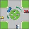 This case involves a cyclist, Javad Behragam, and a pickup truck driver, Peter Paviglianiti. The two collided in a traffic circle at West 10th Avenue and Birch Street in Vancouver. The trial was held to determine who was liable for the collision, the cyclist or the driver.